 |
Boletín Comisión de
Geoespeleología
FEDERACIÓN ESPELEOLÓGICA DE
AMÉRICA LATINA Y DEL CARIBE, A.C.
(FEALC)
BOLETÍN INFORMATIVO DE LA
COMISIÓN DE GEOSPELEOLOGÍA
No.
42, Diciembre 2003
Coordinador:
Prof. Dr. Franco Urbani
Sociedad Venezolana
de Espeleología. Apartado 47.334, Caracas 1041A, Venezuela.
Telefax: (58)-212-272-0724,
Correo-e: urbani@cantv.net
Este Boletín es de carácter informal -no arbitrado-
preparado con el objetivo de divulgar rápidamente las actividades
geoespeleológicas en la región de la FEALC. Sólo se difunde por
vía de correo electrónico. Es de libre copia y difusión y explícitamente
se solicita a quienes lo reciban que a su vez lo reenvíen a otros
posibles interesados, o lo incluyan es páginas web. Todos los
números anteriores están disponibles. Igualmente se pide que obtengan
copias en papel para las bibliotecas de sus instituciones. Se
solicitan contribuciones de cualquier tipo y extensión para su
divulgación.
Índice
Copied
from http://www.karto.ethz.ch/neumann-cgi/cave_symbol.pl
Cave Symbols
The official UIS list
UIS working group on Cave Survey and Mapping
| Symbol: Survey Points |
| Image Plan |
Image Section |
|
|
Explanation
The main survey points have been kept in the list, but often they are no longer
shown on fair copies.
Translations
Croatian: Mjerne tocke
Dutch: Meetpunten
French: Point de relevé principal
German: Messpunkte
Italian: Caposaldo principale
Romanian: Punct topografic principal
Slovene: Merilne tocke
|
| Symbol: Survey Points |
| Image Plan |
Image Section |
|
|
Explanation
as
before
Translations
Croatian: Stijene kanala/ galerije
Dutch: gang-omlijning
French: Dessin de galerie
German: Gangumriss
Italian: Contorno della cavitr
Romanian: Conturul gaeriei
Slovene: Stene rova
|
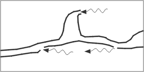
| Symbol: Underlying Passage |
| Image Plan |
Image Section |
|
|
|
Explanation
As an additional help to distinguish the lower from the upper passage
it is recommended to stop the line of the lower gallery before it
reaches the upper gallery. To distinguish this symbol from the "presumed
dimensions of space" (see below) it is recommended to draw short
dashes with wide spacing.
Translations
Croatian: Kanal na nizoj etazi
Dutch: Onderliggende gang
French: Croisement de galeries
German: Unterlagernde Gänge
Italian: Cavitr sottoposta
Romanian: Galerii suprapuse
Slovene: Spodaj lezeci rov
|
| Symbol: Too
narrow Continuation |
| Image Plan |
Image Section |
|
|
|
Explanation
as before
Translations
Croatian: Preuski prolaz
Dutch: te nauwe doorgang
French: Continuations trop étroites
German: Fortsetzung zu eng
Italian: Prosecuzione troppo stretta
Romanian: Impenetrabil
Slovene: Preozko nadaljevanje
|
| Symbol: continuation Possible |
| Image Plan |
Image Section |
|
|
|
Explanation
as before
Translations
Croatian: Moguci nastavak
Dutch: mogelijke doorgang
French: Continuation possible
German: Fortsetzung möglich
Italian: Prosecuzione possibile
Romanian: Continuare posibila
Slovene: Mozno nadaljevanje
|
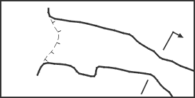
| Symbol: Presumed dimensions
of space |
| Image Plan |
Image Section |
|
|
|
Explanation
The dashes should be long and the spacing narrow (see "underlying
passages").
Translations
Croatian: Pretpostavljena velicina kanala/ galerije
Dutch: Geschatte maten van de ruimte
French: Dimensions spatiales présumées
German: Geschätzte Gangdimensionen
Italian: Dimensioni presunte della cavitr
Romanian: Dimensiuni spatiale presupuse
Slovene: Predvidena veliksot prostora
|
| Symbol: Ceiling form |
| Image Plan |
Image Section |
|
|
|
Explanation
The symbol for the form of the ceiling of a cave is also used for the
dripline and for chimneys.
Translations
Croatian: Oblik stropa
Dutch: vorm van het plafond
French: Forme du plafond
German: Deckenform
Italian: Morfologia del soffitto
Romanian: Forma tavanului
Slovene: Oblika stropa
|
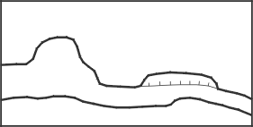
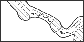
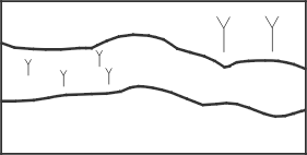
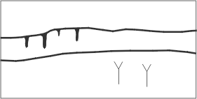
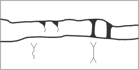
| Symbol: Dripline - Profile |
| Image Plan |
Image Section |
|
|
|
Explanation
The dripline can give valuable information especially for smaller caves
and overhangs. It describes the actual entrance to a cave including
the upper ceiling region and should therefore not be omitted. At
the dripline the cave begins.
Cross-sections are of major importance for the understanding
of a passage. For each map passage cross-sections must
be drawn. The arrows indicating the direction of view
are done differently, a clear indication is, however,
necessary. Translations
Croatian: kapnica (pocetak spilje) - Presjek
Dutch: druplijn - profiel
French: Entrée de cavité - Sections transversales
German: Trauflinie - Querschnitt
Italian: Limite esterno della grotta - Sezione trasversal
Romanian: Intrare-sectiune transversala
Slovene: Zunanja meja jame - profil
|
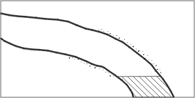
| Symbol: Steps |
| Image Plan |
Image Section |
|
|
|
Explanation
This symbol is well known, just don't forget that the little dashes are
always to be orientated downwards!
Translations
Croatian: Skok
Dutch: treden
French: Marches, ressauts
German: Stufen
Italian: Salto
Romanian: Saritoare
Slovene: Stopnja
|
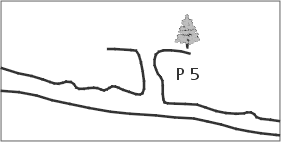
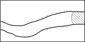
| Symbol: Pit |
| Image Plan |
Image Section |
|
|
|
Explanation
The filled or empty triangle have been replaced by dashed lines for two
reasons: First, the dashed line is easier to draw, secondly it is
unclear even to most draughtsmen whether the empty triangles represent
the smaller or the higher steps or when they should be filled (at
5 m or 10 m?).
Translations
Croatian: Vertikalni kanal (jama u objektu)
Dutch: Put/schacht
French: Puits (profondeur en mctres)
German: Schacht
Italian: Pozzo
Romanian: Put (adâncime în metri)
Slovene: Brezno
|
| Symbol: Pit open
to Surface |
| Image Plan |
Image Section |
|
|
|
Explanation
as before
Translations
Croatian: Vertikalni ulaz (otvor jame)
Dutch: Put, Daglichtput
French: Puits débouchant en surface
German: Schacht mit Oberflächenöffnung
Italian: Pozzo 2
Romanian: Aven
Slovene: Vhodno brezno
|
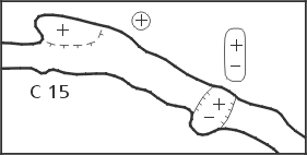
| Symbol: Aven/Aven-pitchs |
| Image Plan |
Image Section |
|
|
|
Explanation
The plus and minus signs can be written inside or outside the cave. For
reasons of clearness they should be encircled when written outside
the cave. We agreed to the following procedure to indicate the difficulty
of a drop or a pitch: If the drop can be climbed without gear, there
is only the number (in meters) written. If gear is needed, any letter
precedes the number. This way, the use of most countries is respected.
It is optional to draw the anchor points and ropes into the longitudinal
section.
Translations
Croatian: Dimnjak/ Dimnjak iznad jame
Dutch: schoorsteen - put
French: Cheminée-Puits-cheminée
German: Schacht - Schlot
Italian: Camino - Pozzo-Camino
Romanian: Horn - Horn-put
Slovene: Kamin - brezno s kaminom
|
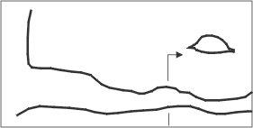
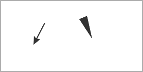
| Symbol: Gradient
Arrows - Entrance Arrow |
| Image Plan |
|
|
|
Explanation
The differentiation between gradient arrows inside and outside the cave
is now omitted. An arrow indicating the entrance was added to the
list.
Translations
Croatian: Smjer nagiba - Ulazna strelica
Dutch: Daal-pijlen Ingangs-pijl
French: Flcche de gradient - Flcche indiquant l'entrée de la cavité
German: Gefällepfeile - Eingangspfeil
Italian: Freccia di gradiente - Freccia per l'ingresso
Romanian: Directia de panta-Saggeata indicând intrarea
Slovene: Smer naklona - puscica za vhod
|
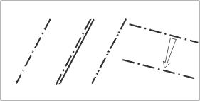
| Symbol: Gradient Lines |
| Image Plan |
|
|
|
|
Explanation
Gradient lines are the most common methods to illustrate the ground structure.
As on geographic maps narrow spacing indicates a steep and wide spacing
a gentle slope.
Translations
Croatian: Slojnice (nagibne linije)
Dutch: Overgangslijnen
French: Lignes de gradient
German: Gefällelinien
Italian: Linee di Gradiente
Romanian: Linie de panta
Slovene: Naklonske crte
|
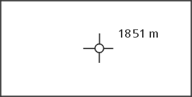
| Symbol: Altitude
above Sea level |
| Image Plan |
|
|
|
|
Explanation
This symbol has also been kept for reasons of consistence and designates
the altitude above sea-level used in the map. It is highly recommended
to write 1880 m. instead of just writing 1880. Generally maps are
all to be done in SI units.
Translations
Croatian: Nadmorska visina (m.n.m)
Dutch: Hoogte boven zeeniveau
French: Altitude au-dessus du niveau de la mer
German: Höhenangaben (Seehöhe)
Italian: Quota s.l.m.
Romanian: Altitudini deasupra nivelului marii
Slovene: Nadmorska visina (m.n.m.)
|
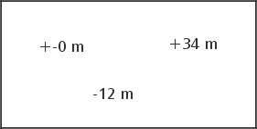
| Symbol: Difference
in Elevation |
| Image Plan |
|
|
|
|
Explanation
in Relation to the entrance, as before
Translations
Croatian: Visinska razlika
Dutch: Hoogteverschil
French: Altitude relative r l'entrée de la cavité
German: Höhendifferenz
Italian: Differenza di quota
Romanian: Altitudine relativa de la intrare
Slovene: Visinska razlika
|
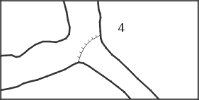
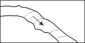
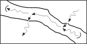
| Symbol: Joint - Fault
- Bedding Plane - Inclined Joint |
| Image Plan |
|
|
|
|
Explanation
These symbols can be quite important for the understanding of the cave.
Please use the symbols proposed here only when there's no appropriate
set of symbols at the geological survey of your country. It is also
recommended not to use any geological symbol unless one is totally
sure about its nature. The arrow connecting two joint symbols is
normally only used in the plan. It shows whether a cave crosses the
same joint several times or whether it follows the joint itself.
Translations
Croatian: Pukotina - Rasjed - Geoloski sloj - Nagnuta pukotina
Dutch: Breuk - Verschuiving - Laagvoeg
French: Fracture - faille - joint de strate - fracture inclince
German: Kluft - Verwerfung - Schichtfuge - schräge Ebene
Italian: Frattura-Faglia-Stratificazione
Romanian: Fractura-Falie-Fata de strat-Fractura înclinata
Slovene: Razpoka - prelom - geoloska plast - nagnjena razpoka
|
| Symbol: Lake - Flowing
Water |
| Image Plan |
Image Section |
|
|
|
Explanation
as before
Translations
Croatian: Jezero - Vodeni tok
Dutch: Meer - Stromend water
French: Lac-eau courante
German: Seen und fliessende Gewässer
Italian: Lago-Corso d'acqua
Romanian: Lac - apa curgatoare
Slovene: Jezero - vodni tok
|
| Symbol: Sump |
| Image Plan |
Image Section |
|
|
|
Explanation
as before. As an option it is possible to stop the crosshatching in order
to draw the characteristics of the sump. This possibility, especially
useful in longer sumps, is also shown.
Translations
Croatian: Sifon
Dutch: sifon/watergevulde gang
French: Siphon
German: Siphon
Italian: Sifone
Romanian: Sifon
Slovene: Sifon
|
| Symbol: Cascade
- Waterfall |
| Image Plan |
Image Section |
|
|
|
Explanation
The symbol for waterfall is the same as the one for drop. To show flowing
water one can draw an arrow indicating the flow before or at the
side.
Translations
Croatian: Vodopad
Dutch: Cascade - Waterval
French: Cascade / Chute d'eau
German: Wasserfall
Italian: Cascata
Romanian: missing
Slovene: Slap
|
| Symbol: Spring -
Sink |
| Image Plan |
Image Section |
|
|
|
Explanation
Springs or sinks which flow sideways in or out of a cave don't need a
half circle to be characterised, whereas water inlets and outlets
in the ground should be marked with a half-circle to distinguish
them clearly from normal flowing water.
Symbols for temporary waters of all kinds have been
omitted alltogether because of the following reasons:
Hydrologically many water courses are also dry in dry
times and are therefore also temporary. Adding to that,
there have been many different symbols in the old symbol
lists that would severely extend this list. One may add
a note on temporary waters to the cave description.
Translations
Croatian: Izvor - Ponor
Dutch: Bron - verdwijnpunt
French: Source / perte
German: Quelle - Ponor
Italian: Sorgente - Inghiottitoio
Romanian: Izvor - Ponor-Pierdere de apa
Slovene: Izvir - ponor
|
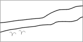
| Symbol: Widespread
Water Inlet - Seeping |
| Image Plan |
Image Section |
|
|
|
Explanation
There is no special symbol any more. It is needed to draw several ± parallel
arrows indicating the flow. For seeping of a watercourse in sediment
the semicircle is also used in the plan! In the longitudinal section
the direction of the arrow can be bent towards the bottom to hint the
seeping.
Translations
Croatian: Razveden dotok vode - Sitasti ponor
Dutch: wijdverspreide waterinvoer - sijpels
French: Arrivée d'eau diffuse - Suintement d'eau dans un sédiment
German: Tropfwasser - Sickerwasser
Italian: Afflusso d'acqua diffuso - Infiltrazione nel detrito
Romanian: Aport de apa difuz - Infiltratii
Slovene: Razvejan pritok vode - ponikujoca voda
|
| Symbol: Scallops,
Flutes in General, Direction of Paleoflow |
| Image Plan |
Image Section |
|
|
|
Explanation
Flow Casts (Scallops): as before.
Flute: The differentiation between erosional and corrosion
flutes has been omitted, because, especially with flutes
on lateral walls, they cannot always be identified correctly.
The new symbol can be rotated; if the semicircle is on
top, it shows a flute on the ceiling, etc.
Paleoflow: This very useful symbol is not only used
with scallops, but also with ripple marks, imbrications
and other features. In addition it might be used in lava
caves to show the flow direction of the lava.
Translations
Croatian: Vrtlozni lonci - Zljebici (fasete) - Smjer fosilnog toka
Dutch: Erosie koepels, kolkgaten, richting van de paleo-stroom
French: Coupoles d'érosion - marmites - courant d'ccoulement fossile
German: Kolke - Fliessfacetten - Paläofliessrichtung
Italian: Scallops - Scanellature in general - Direzione del paleoflusso
Romanian: Cupole de eroziune - marmite - curent de apa fosil
Slovene: Kotlice - zlebici (fasete) - smer starega toka.
|
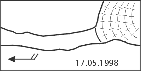
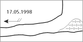
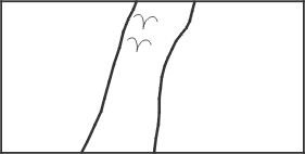
| Symbol: Air
draught - Ice/Snow/Firn |
| Image Plan |
Image Section |
|
|
|
Explanation
Air draught: This is a well known symbol. It should always include the
date of measurement. The symbol now uses always two feathers! The
date of measurement should be written in the standard dd-mm-yyyy
format!
Ice/Snow/Firn: The old star symbol used for snow hasn´t
been satisfactory for quite some time as it is very time
consuming to draw and the ground structure cannot be
shown. Added to this, it can easily be mistaken for the
crystal symbol. The old symbol for ice is confusingly
similar to true gradient lines. Taking all this into
consideration we agreed on the following solution: Snow
is transformed to firn and subsequently to ice. By morphology
and composition all three substances are the same, therefore
it should be represented by the same symbol. The one
that has been chosen is easy to draw, shows the ground
structure and cannot be mixed up.
Translations
Croatian: Propuh - Led/Snijeg/Inje
Dutch: luchtstroom - Ijs-Sneeuw-firn
French: Courant d'air - Glace/neige/givre
German: Luftzug - Eis/Schnee/Firn
Italian: Corrente d'aria - Ghiaccio - Neve - Firn
Romanian: Curent de aer - Gheata-zapada-firn
Slovene: Prepih - led/sneg/srez
|
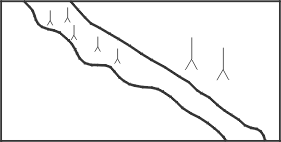
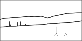
| Symbol: Stalagmites |
| Image Plan |
Image Section |
|
|
|
Explanation
as before
Translations
Croatian: Stalagmiti
Dutch: Stalagmieten
French: Stalagmites
German: Stalagmiten
Italian: Stalagmiti
Romanian: Stalagmite
Slovene: Stalagmiti
|
| Symbol: Stalactites |
| Image Plan |
Image Section |
|
|
|
Explanation
as before
Translations
Croatian: Stalaktiti
Dutch: Stalactieten
French: Stalactites
German: Stalaktiten
Italian: Stalattiti
Romanian: Stalactite
Slovene: Stalaktiti
|
| Symbol: Sinter
Curtains - Pillars |
| Image Plan |
Image Section |
|
|
|
Explanation
Calcite Curtains: The presented solution is not easily understood at
first sight but seems to be the best (alternatively you draw the
curtains into your map).
Calcite pillars: as before
Translations
Croatian: Zavjese od sigovine - Stupovi
Dutch: Gordijnen - Pilaren
French: Draperies stalagmitiques - Piliers stalagmitiques
German: Sintervorhänge - Tropfsteinsäulen
Italian: Cortina di concrezione - Colonna
Romanian: Draperii stalagmitice - coloane-pilieri stalagmitici
Slovene: Sigova zavesa - steber
|
| Symbol: Helictites
- Soda Straws - Crystals |
| Image Plan |
Image Section |
|
|
|
Explanation
Helictites: This symbol is as eccentric as the formation itself and is
therefore easily understood.
Soda Straws: This symbol doesn´t need any further
explanations.
Crystals: For reasons of international understanding
the letters identifying the minerals should be avoided,
first because correct mineral identification is often
not as easy as it may seem, and second because a C for
calcite is an K in German and a # in Chinese. In general
we do not recommend the use of letters as symbols on
the actual map. The resulting babylonic confusion can
be lethal for the understanding.
Translations
Croatian: Heliktiti - Spageti - Kristali
Dutch: excentrieken - macaronies - kristallen
French: Excentriques/Helictites - Spaghettis - Cristaux
German: Excentriques - Spaghetti - Kristalle
Italian: Concrezione eccentrica - Spaghetti - Cristalli
Romanian: Excentrite-Helictite - macaroane - cristale
Slovene: Heliktiti - spageti (cevcice) - kristali
|
| Symbol: Sinter
Pools |
| Image Plan |
Image Section |
|
|
|
Explanation
as before
Translations
Croatian: Zasigane kaskade
Dutch: Sinter-bekkens
French: Gours
German: Sinterbecken
Italian: Grandi vasche - Vaschette di concrezione
Romanian: Gururi
Slovene: Sigove ponvice
|
| Symbol: Flowstone
- Wall Calcite - Moonmilk |
| Image Plan |
Image Section |
|
|
|
Explanation
Flowstone: Often this or a similar symbol is also used for clay (see
there).
Wall Calcite: as before
Moonmilk: To avoid mistaking this symbol for the guano
symbol an additional bow has been added to the usual
m
Translations
Croatian: Zasigano tlo - Zasigana stijena - Spiljsko mlijeko
Dutch: Bodemdruipsteen - afzettingen op de wand - bergmelk
French: Concrétionnement au sol - Concrétionnement sur
les parois - Mondmilch
German: Bodensinter - Wandsinter - Mondmilch (Bergmilch)
Italian: Colata a pavimento - Colata parietale - Latte di Monte
Romanian: Planseu concretionat - concretiuni parietale - montmilch
Slovene: Zasigano pobocje - zasigana stena - jamsko mleko
|
| Symbol: North
Arrow Geographic and Cartesic |
| Image Plan |
|
|
|
|
Explanation
On several maps, information on declination is missing or is incomplete,
which makes the calculation of geographic north almost impossible.
Beside the normal North arrow one must specify whether one relates
to geographic, magnetic, or cartographers north. If one is relating
to magnetic north the date of measurement must be mentioned. Both
versions shown are equivalent.
Translations
Croatian: Zemljopisni (geografski) i Kartezijski sjever
Dutch: Noord pijl Geografisch en Cartesisch
French: Nord géographique et cartographique
German: Geographisch und Kartesisch Nord (Gitternord)
Italian: Nord Geografico et Cartesiano
Romanian: Directia nord - geografic and cartigrafic
Slovene: Geografski sever - Kartezijski sever
|
| Symbol: North Arrow
Magnetic |
| Image Plan |
|
|
|
|
Explanation
On several maps, information on declination is missing or is incomplete,
which makes the calculation of geographic north almost impossible.
Beside the normal North arrow one must specify whether one relates
to geographic, magnetic, or cartographers north. If one is relating
to magnetic north the date of measurement must be mentioned.
Translations
Croatian: Magnetski sjever
Dutch: Noordpijl Magnetisch Noorden
French: Nord magnétique
German: Magnetisch Nord
Italian: Nord Magnetico
Romanian: Directia nord magnetic
Slovene: Magnetni sever
|
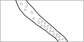
| Symbol: Blocks
- Debris |
| Image Plan |
Image Section |
|
|
|
Explanation
as before. The size can be modelled on the reality.
Translations
Croatian: Blokovi - Krslje
Dutch: Blokken - rol-steentjes
French: Blocs, débris
German: Blockwerk, Geröll
Italian: Massi - Detriti a spigoli vivi
Romanian: Blocuri - prabusiri
Slovene: Bloki - grusc
|
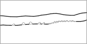
| Symbol: Pebbles |
| Image Plan |
Image Section |
|
|
|
Explanation
as before. The size can be modelled on the reality.
Translations
Croatian: Sljunak
Dutch: Kiezels
French: Cailloux
German: Kiesel
Italian: Ciottoli - Detriti a spigoli arrotondati
Romanian: Pietris
Slovene: Prodniki
|
| Symbol: Clastic
sediments: Sand - Silt - Clay - Humus |
| Image Plan |
Image Section |
|
|
|
Explanation
With the exception of humus this group is a sediment whose grain size
and therefore names depend on the velocity of current of the carrying
water. In flowing water sand is deposited whereas in standing water
clay is deposited. In contrast to this the flowstone (see there),
which is a chemical precipitchation, does not represent the velocity
of flow but the chemical equilibrium. As flowstone occurs quite frequently
a special symbol needed to be found. The small parallel dashes did
a good job as they also showed the ground structure. Unfortunately
several surveyors characterised clay by a series of small dashes,
which can lead to some confusion.
Translations
Croatian: Klasticni sedimenti: Pijesak - Mulj - Glina - Humus
Dutch: Sedimenten: Zand - Zilt - Klei/Leem - Humus
French: Sédiments clastiques : Sable, limon, argile et humus
German: Klastische Sedimente: Sand - Schlamm - Lehm - Erde
Italian: Sedimento fine: Sabbia - Limo - Argilla - Humus
Romanian: Sediment clastic - nisip, mâl, argila, humus
Slovene: Klasticni sedimenti: Pesek - mulj - glina (blato) - prst
|
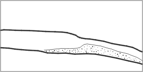
| Symbol: Clay-Covered
Walls |
| Image Plan |
Image Section |
|
|
|
Explanation
This symbol can be used to show flooded zones. To show a mud coating,
one thin dotted line is drawn behind the cave walls.
Translations
Croatian: Glinom prekrivene stijene
Dutch: Klei-bedekte wanden
French: Parois couvertes d'argile
German: Lehmüberzogene Wände
Italian: Pareti ricoperte di argilla
Romanian: Pereti acoperiti cu argila
Slovene: Z glino prekrite stene
|
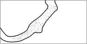
| Symbol: Guano |
| Image Plan |
Image Section |
|
|
|
Explanation
as before
Translations
Croatian: Guano
Dutch: Guano
French: Guano
German: Guano
Italian: Guano
Romanian: Guano
Slovene: guano
|
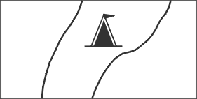
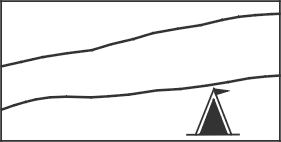
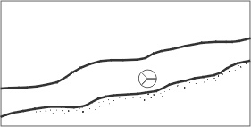
| Symbol: Camp |
| Image Plan |
Image Section |
|
|
|
Explanation
as before
Translations
Croatian: Bivak
Dutch: Kamp/Bivak
French: Camp
German: Biwak
Italian: Campo, Bivacco
Romanian: Tabara
Slovene: bivak
|
| Symbol: Height
of a Room |
| Image Plan |
|
|
|
|
Explanation
An indication on height can be useful for a caver who doesn´t draw
longitudinal sections. But since this is highly recommended (see documentation
of the 9. National Nongress 991, Charmey) this symbol is not going to
be used very often.
Translations
Croatian: Visina galerije
Dutch: Hoogte van een zaal
French: Hauteur d'une galerie / salle
German: Raumhöhe
Italian: Altezza di un ambiente
Romanian: Înaltime (alerie-sala)
Slovene: Visina prostora
|
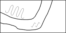
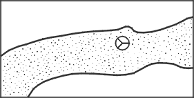
| Symbol: Anostomosen
- Karren |
| Image Plan |
Image Section |
|
|
|
Explanation
as before
Translations
Croatian: Anastomoza - Skrape
Dutch: Vlechtende micro-gangetjes - Karren
French: Anastomoses - Lapiez
German: Anostomosen - Karren
Italian: Anastomosi - Karren
Romanian: Anastomoze - lapiezuri
Slovene: Anastomoza - skraplje
|
| Symbol: Cauliflower-Calcite
/ Disk |
| Image Plan |
Image Section |
|
|
|
Explanation
These two symbols for calcite are of a regional importance and can be
quite useful.
Translations
Croatian: Karfioli - Nakapne ploce
Dutch: Kalk-bloemkool - Disk
French: Concrétionnement en choux-fleurs - Disques
German: Blumenkohlsinter / Disk
Italian: Cavolfiori - Dischi di concrezione
Romanian: Clusterite-Coralite - discuri
Slovene: Karfjolce - kapniske plosce
|
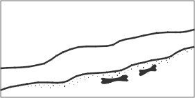
| Symbol: Bones |
| Image Plan |
Image Section |
|
|
|
Explanation
This symbol does not need any further explanation.
Translations
Croatian: Kosti
Dutch: Botten
French: Ossements
German: Knochen
Italian: Ossa
Romanian: Oase
Slovene: kosti
|
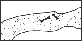
| Symbol: Human
Activity |
| Image Plan |
Image Section |
|
|
|
Explanation
This symbol is used for man-made changements and/or relicts in caves,
including e.g. artwork / drawing / pottery / old mining sites / human
bones. Preferably, it will be used for historic/prehistoric changements!
Translations
Croatian: Ljudska aktivnost
Dutch: Menselijke activiteit
French: Traces d'activité humaine
German: Menschliche Artefakte
Italian: Modificazioni umane
Romanian: Urme de activitate antropica
Slovene: Clovekove spremembe oz. ostanki
|
Volver indice
Tomado de: http://www.earthsci.unibe.ch/people/praezis/symbol2.html
http://www.earthsci.unibe.ch/people/praezis/symbol1.html
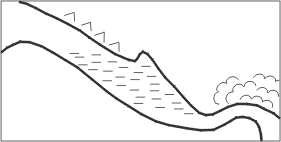
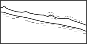
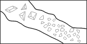
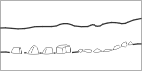
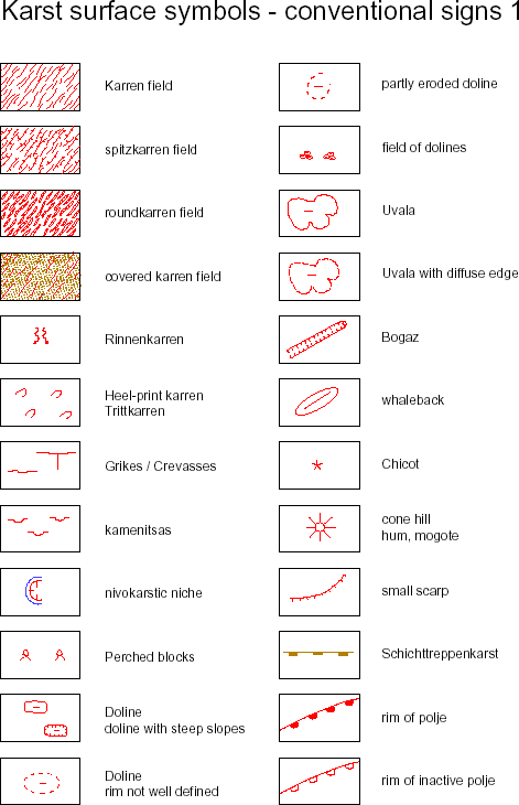
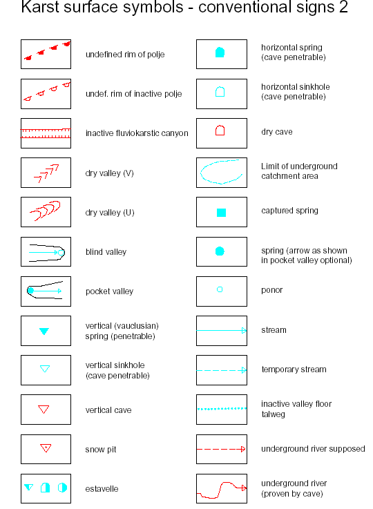
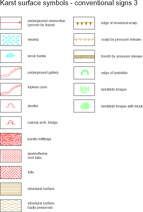
A proposition for Karst surface conventional symbols
Karst surface symbols, used mainly by geomorphologists, but sometimes
also by geologists, contain important information on a map. Until
now, however, the surface symbols were only partly standardised,
often on a national (or even organisational) scale. This led to
a possible misunderstanding of the map or to a difficult reading
that needed to consult the legend very often. The utility to standardize
the karst surface symbols is therefore given.
The following propositions
had been elaborated on the base of several regional or national
lists, most of them coming from Europe. Two
of the main contributors are the work of F. JOLY and A. BINI et
al., that were completed and partially adapted to the Swiss Geologic
conventional
signs, and the old UIS entrance symbol set. The present proposition's
aim is:
-
to be a base of information. This means that
the present list is by no means complete, but should constitute
a sound base,
upon which
the individual countries and/or organisations can build up their
own symbol list they need for their specific maps
-
therefore to
stimulate discussions amongst karst geomorphologists and geologists
-
to get to a generally adopted, universally acknowledged
symbol set that will facititate the reading of geomorphologic
maps.
It therefore
follows the UIS Cave Signatures which had been elaborated on the
same way.
The present proposition had been elaborated by the UISIC Working
group Survey and Mapping, in contact with the IGU Karst Commission
and other interested persons. Attention has been paid that the
presented symbols can be generated or propagated by computer programs,
since
most of today's cartography is computer-aided.
The author of the present list kindly asks for suggestions, improvements,
and comments on the present proposition!
The address is:
Ph. Haeuselmann Haldenstr. 32, 3014 Bern - Switzerland, 0041 31 3320174,
praezis@geo.unibe.ch
Volver indice
|
|